 Dorothee International
 25th Oct I reached Arizona some days earlier as planned. My first stop in this state was at a coffee shop in nowhere:

The Coffee Shop in “Nowhere”
While on my road trip I have been thinking about Route 66 and that I should find out, where it is as well as my next trip throughout the USA should be on that route. Therefore I was happy, when I could read in Kingman, that I already was there (even it was a tiny short part of the US Mother Road). I stayed here for the rest of the day and visited the visitors center as well as the three small museums (The Route 66 Museum, the Carlos Elmer Photo Gallery and the Bob Boze Bell’s ‘The 66 Kid’ Exhibition), in the same building, the Powerhouse. Furthermore I took photos of all things related to Route 66 and had lunch at Mr. D’z, which had an interior with the same theme.

Kingman – Route 66
See more photos of Kingman by clicking on photographs.
In addition to that I was at the library and checked my Euro-account. The result was positive, even there were only €0.39 left, but the next pension will come soon and I still have my Swedish account with a much higher positive balance.
I had asked at the visitors centre for a campground, but they told me, that there only is a RV-Park. Though I was going further and filled my car at a Loves gas station. They had problems with their pumps and I have got fuel for $0.43 and $0.08. I got confused and angry, because I paid with card and had the second time already prepaid $40.00. There was no other way then the assistant had to draw my card one more time. First he did not tell me, that it was for putting back the amount on my card, though I told him: “No, I do not pay twice.” At the end all went well, but I checked my account afterwards often for being sure, that no double amount will be taken.
I found the Circle S Campgrounds unexpected and asked if it would be possible to stay there with my car, though I got to know, that they had tent sites as well and I did get one for the night. I finally could take a shower and enjoyed it very much. Furthermore wi-fi was offered for free and there were even opportunities to charge my device. Anyway the fee was only $15 / night. The shower was coin operated. If I remember right, it was only $1.

Camping at Circle S
26th Oct I awoke with the sun around 6am, but did not dress before 7.30am. I enjoyed my breakfast at the table, which belonged to my tent site and was invited for a freshly brewed mug of coffee by the owner of the campground. Afterwards I followed Route 66 as long as it was possible in the direction of the Grand Canyon. I stopped several times that day. My first stop was in Hackberry for the nature as well as the General Store, where I by the way bought a t-shirt for $20 with motives from Route 66.

Hackeberry General Store at Route 66
See more photos of Hackberry by clicking on photographs.
The second stop was in Peach Springs, a Native area, where I filled my car, bought food and at the Hualapai lodge (called after the tribe and the mountain) a souvenir (a bracelet). The third stop this day was in Seligman. Here I bought additional food for lunch at the General Store and stamps at the Post Office.

Seligman at Route 66
See more photos of Seligman by clicking photographs.
In Williams I had my lunch close to the Ranger station:

Williams – Close to Ranger Station
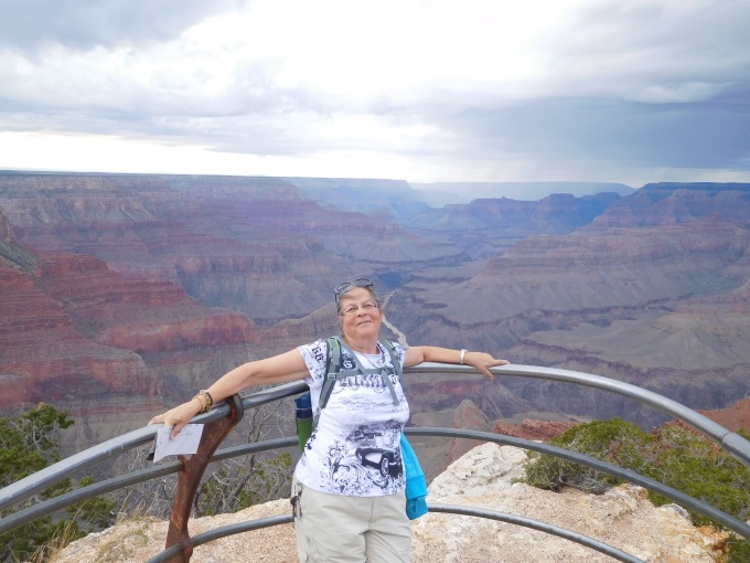
Between 4 and 5pm I entered the Grand Canyon National Park and had to pay $30.00 – the same amount again like a family of five. I was allowed to stay in the park for a whole week. Before it got dark I still had the possibility to walk for a while along the South Rim. Maybe I should explain here, that so late of the year only the South Rim is open. One can, of course, still drive around the North Rim as well, but no facilities (campsites, visitors centre or shops) are running this time of the year. If you now are awaiting, that I was standing on the skywalk, I have to explain to you, that the Grand Canyon Skywalk is situated in the West of the Grand Canyon and not a part of the National Park either. It was built for and is operated by the Hualapai tribes.

Grand Canyon NP
However the visitors centre was already closed for the day, when I arrived there and even the office of the campsite was not open anymore, but two female rangers explained the system for late arrivals and which space I could use. They also told me, that it was OK to pay the next morning. – By the way before dark I also have seen mule deers, which are usual in the Grand Canyon National Park.

Grand Canyon NP – Mule Deer
The campsite itself was nothing special. My site (Pine Street 300) was hard to drive into, because the road was a “One Way”-road. Had it been allowed to come from the other direction, it would have been much easier. However the restrooms were very close, which made worth it.
27th Oct I awoke after a cold night with only +6°C. I hade my breakfast at the campsite, without coffee, of course. The table with benches was not clean, but I used my inflatable cushion and had a plastic bag on the table. Around 9am I left the campground after I had paid the fee for the night. At the “Market Plaza” there is a General Store and café as well, though I bought a coffee and later on new batteries for my headlight as well as crisp bread and a chocolate. With all the necessary for the day, I drove and visited the visitors center for a free map and also asked about the North Rim. With the information provided I decided to go by car to the “Desert View”, because no shuttle was going there as well as this place was 25 miles (40 km) away from the visitors centre. The drive itself is scenic and passes historic places. One of them are the Tusayan ruins. I walked around, one more time in my life wondering about, what archaeology can tell us and also that not all Natives lived in tipis.

Tusayan Ruins
At the Desert View point I used the Watchtower. Unfortunately it became foggy, which is not unusual for the Grand Canyon area. Anyway I made photographs from all levels – inside and outside the tower.

View from Desert View Watchtower
Around 1pm I was already hungry again and ordered one of the cheaper meals: A Chili Dog. I expected a spicy hotdog, but it was a hotdog coming with Chili con Carne. Though it was enough for me to become full.

The Chili Dog
On the way back to the Grand Canyon Village I stopped at every viewpoint. The first one was Navajo Point, the highest overlook point at the South Rim of the Grand Canyon at about 7500 feet of elevation.

It was followed of a viewpoint without signs, though it was not an official viewpoint, but also here the view was breathtaking.

No Name View Point
The next stop I made at Moran Point, here are three main rock groups clearly visible. The Layered Paleozoic Rocks represent the sedimentary rocks that make up most of the Grand Canyon’s depth. The Grand Canyon Supergroup represents a significant portion of the canyon’s geologic record even though it is only in isolated remnants, visible at only a few spots along the rim. The Vishnu Basement Rocks are the oldest at the canyon, consisting of both metamorphic and igneous rock. By the way the name is Spanish.

Moran Point
The last of the official viewpoints was the Grand Viewpoint with panoramic views of the Grand Canyon from east to west, including several bends of the Colorado River to the east.

Grand Viewpoint
In addition to these, other tourists and me stopped at turn outs. From one of them the “Duck on the Rocks” was clearly seen.
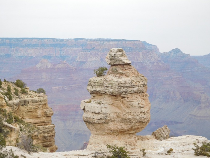
The Duck
This day I also was going to the Pipe Creek Vista by car. It was actually the same trip.
At Pipe Creek Vista
Having a little more time before dark I was going further to the Grand Canyon Village of two reasons. I hoped I would find a supermarket, but I did not. In that tiny village, most of the streets were only allowed for residents. The other reason was the well advertised Train Depot. This railway station is one of three remaining railroad depots in the United States built with logs as the primary structure material, but I could not park somewhat close to it and therefore was not able to take a photo of it.
I had my evening meal at the Deli café at the Market Plaza (in the General Store) in a hurry, because they already closes at 6pm – the store is open until 8pm. I ordered a cheap sandwich and the assistant looked disappointed, that I did not order more. I also got disappointed and not only by the opening hours, but that the wi-fi was not working. There are only a few places with wi-fi and this was the closest one to the campsite. Before I was going back to the campsite I used the nearby ATM. It did not ask me like it is usual, if I really will take out money there, because a fee will be charged. Though I thought there was no fee, but some days later it was drawn of my account.
I booked the same site again at the campground, because it was so close to the restroom and I was a late arrival again. I did not decide in the morning, if I would stay there again. That night I did not freeze so much, because I dressed very well and also put the blanket around me inside the sleeping bag from the very first moment. By the way I charged my tablet in the restroom. It took hours, therefore I only charged it 50%. Anyway I spent a lot of time in the restroom. Luckily I got a nice chat with two women in their 50s.
28th Oct I awoke already at 6am, but did not dress before 8am. After breakfast I paid for the night, which had been similar as the last night. I parked my car close to the visitors centre and was going by shuttle bus to Hermits Rest. I walked around and used also Hermits Trail for a while, because I hoped for a better opportunity for a photo, but there was not. Before I walked eastwards to Powell Point with several viewpoints in between, I bought a sandwich at the so-called restaurant, which was not worth it’s name. They only sold pre-made stuff in plastic and nothing better than sandwiches.

Trail Sign at Hermits Point
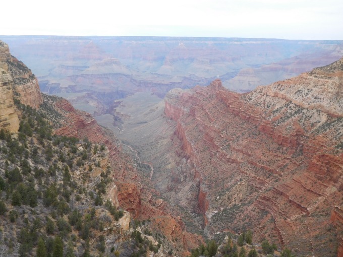
From this direction the next viewpoint was the Pima Point. Here the trail began to become dirty, which means: not paved. That was not really a challenge, but the trail was very close to the edge, though I felt uncomfortable. I continued anyway, always as far from the edge as possible. The viewpoints themselves were secured.

View of Part of Grand Canyon and Colorado River
From the Monument Creek Vista, the trail was paved again and also further from the edge. This point was followed by The Abyss, Mohave Point and Hopi Point.
Save View-Point
The last distance for the day was between Hopi Point and Powell Point and this was dirty again. The dirty trails were even much more narrow as the paved trails.

Dirty Trail
Every viewpoint was also a bus stop, but only to the West, that means to Hermits Rest. Eastbound the bus only stops at very few of them. Vehicles were not allowed on this road, but bicycles. The walk I did was only around 10 km, though I was very surprised when me legs hurt so much, that I had to take painkillers, so I could sleep.

Bus Stop
Even my car did not feel well. It leeked lots of water. It left a water lane behind itself, when I was driving back to the campsite. This night I had site 299 Pine Street. Number 300 was already pre-booked before I booked in the morning and that site was actually even better. Because the problem with the car, I was thinking about what to do with the car, even I tried to listen to my music. Before I fell asleep I had decided, that I will drive the car to the Market Plaza, though it is easier to find, if I need help with it, but I would in any case first finish my sightseeing of the Grand Canyon.
29th Oct my day started at 8am again. I was going with the car to the Market Plaza as planned and fortunately the car was not leaking. After a cup of coffee I took the shuttle bus to the Powell Point and started, where I had not completed the day before. I made it this day to the Mather Point and back to the visitors centre. This route was only for 7 to 8 km.
The viewpoints in between both of these are Maricopa, the Trailview Overlook, Grandeur and Yavapai. Only from the Trailway Overlook it is possible to see the village. Furthermore the point gives a view of the Plateau Point and Bright Angel Trails. In addition to that there is a view of the Bill Williams Mountain, the San Francisco Peaks and the Red Butte from the overlook.
It started raining, when I was between Maricopa and the Trailhead Overlook, but first at the overlook it was so heavy that I used my rain cape. Most of the people around had no rain jacket or umbrella with them and got wet. Here were also another visitors centre, restaurants, shops and galleries, though partly people was entering these. I was interested in the art of Native Americans and looked around, too. I have seen lots of things I liked, but because the prices and of some items the size, I did not buy more than a postcard. Even the prices sounded high, most of the items were worth it. The crafts were done during many hours of work. As a budget traveller, I simply cannot afford such things.
I continued to Mather Point and walked then back to the visitors centre, from where I took the shuttle bus to the Market Plaza. Back there I ordered a mini pizza. It was unusual fat, but I had to eat it. I had a lemon pop, too – which I did not like either 😕.
Back at the car I checked if there was water under the car, but there was not. Anyway I did not move the car and slept on the car park (saving $18). This day I booked a bed in a hostel in Flagstaff. I was longing for a warm place and company. Additionally I prepared for leaving the car in that town, if necessary.
30th Oct I awoke at 6:30am and was to the restroom an hour later. When I came back a beautiful bird was sitting on the antenna of my car. I tried to take a photo of it, but it flew away. I had breakfast at the café – an oatmeal (instant, they cook it in the microwave oven). They had not did it well and it was a tiny portion. I was going by shuttle bus to Yaki Point. I had planned to go off at Kaibab Trailhead, but only the eastbound bus did stop there. I walked all the way from Yaki Point to Pipe Creek Vista as well as the visitors centre and took the shuttle back from there to the car, which I still had on the car park of the Market Plaza.
I left the Grand Canyon National Park around 2pm and was driving the hwy 180. Actually I was thinking about to drive to Albuquerque in New Mexico before my car lost so much water, but now I was afraid to drive too much with it. Driving this highway you have a good view on the San Francisco mountains and the Red Mountain very close aside.
For more photos of the Grand Canyon National Park click photographs.
It took not more than two hours to Flagstaff, I found a space on the car park of the hostel and checked in. It was a free hostel, called “Grand Canyon International Hostel”. The building was old, but the hostel clean and cared for. Unfortunately it only had two restrooms/showers on each floor.

Hostel at Flagstaff
I took a walk to the city centre and asked at the visitors centre for a restaurant with lower prices as well as I followed their recommendations. Though I had a meat burrito at the “Downtown Diner“. With the burrito Swiss Rösti was served. It was tasty, the service good and the price affordable. I did not have the camera with me, though all photos were taken the upcoming day. In the evening I used the Internet in the hostel’s lounge.
31st Oct – HALLOWEEN. Yes, in the States it is highly celebrated. I have been told, that Americans become crazy these days. Surprisingly for me, the community decorated the Market place. I had a nice chat about travelling with Jim from Turkey and Michael from the States during the free breakfast. Later on we got company from a female traveller called Morgan. She was also from the US. The hostel offered instant oat meals (for the microwave), toast, butter, jam, tea and coffee.

Flagstaff Railway Station and Tourist Information Center
It was basically t-shirt weather this day, but it was windy. From time to time I had to use my wind jacket and even to close it. I checked out at 10am, put my luggage in my car and walked the town one more time, this time taking photographs, because it is a cosy little town. During this walk I saw the workers decorating the Market Place.

Preparing for Halloween
Around noon I filled my car and left Flagstaff. I drove throughout the desert, but had amazing views of lower mountains and hills as well as sand dunes, which had become mountains. Unfortunately I could not stop and take photos of the partly overwhelming views. I wished I have had video cameras on the top of my car.
For more photos of Flagstaff click photographs.
In Gap I had a coffee and a roll (soft cake), somewhere in an Indian reservation was a viewpoint with a very beautiful view. Here were also some Native women in my age, selling their crafts. I have a heart for these people and looked at their items. I thought, if I buy something, it has to be special and unfortunately for my economy one was selling canoes, carved from stone. One of them is extra ordinary beautiful and now mine.
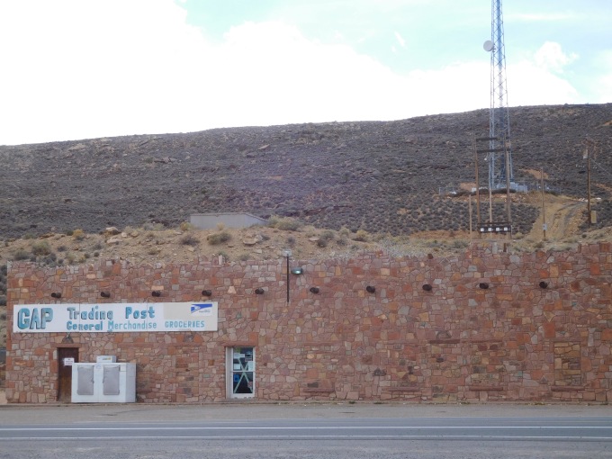
Trading Post
For more photos of GAP and Highway 89 click here!
The last stop in Arizona was in Page at the Glen Canyon Dam. I’m not so very interested in dams. I did grew up with them, but it had a pretty bridge and the canyon with the river was an amazing view.

Glen Canyon Dam
For more photos of the Glen Canyon click here!
To follow my further, please click Utah.
